![](/images/other/stat-length.png)
![Randonnée Marche The Municipal District of Borris-in-Ossory — Mountmellick - Binninea Loop Cullahill - Photo](https://media.geolcdn.com/t/1900/400/ext.pjpeg?maxdim=2&url=https%3A%2F%2Fstatic1.geolcdn.com%2Fsiteimages%2Fupload%2Ffiles%2F1553511878bg_sport_marche.png)
Binninea Loop Cullahill
mlmoroneybb
Utilisateur
![Longueur](/images/other/stat-length.png)
Longueur
10,2 km
![Altitude max](https://static1.geolcdn.com/siteimages/upload/files/1508320355ic_sort_altitude_max_24dp.png)
Altitude max
269 m
![Dénivelé positif](https://static1.geolcdn.com/siteimages/upload/files/1508320355ic_sort_den_pos_24dp.png)
Dénivelé positif
245 m
![Km-Effort](/images/other/stat-length.png)
Km-Effort
13,5 km
![Altitude min](https://static1.geolcdn.com/siteimages/upload/files/1508320355ic_sort_altitude_min_24dp.png)
Altitude min
149 m
![Dénivelé négatif](https://static1.geolcdn.com/siteimages/upload/files/1508320355ic_sort_den_neg_24dp.png)
Dénivelé négatif
244 m
![Boucle](https://static1.geolcdn.com/siteimages/upload/files/16400158638029165_repeat_loop_refresh_sync_direction_icon.png)
Boucle
Oui
Date de création :
2014-12-10 00:00:00.0
Dernière modification :
2014-12-10 00:00:00.0
![Marche](https://static1.geolcdn.com/sitytour/trail-icons/101.png)
--
Difficulté : Moyen
![Scannez ce code QR pour ouvrir la randonnée dans l'application SityTrail](https://capi.geolives.com/qq0zvz2zws4bq2lad0pu/sitytour/trails/97935/qr.png?size=200)
Application GPS de randonnée GRATUITE
À propos
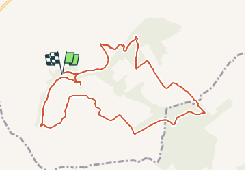
Randonnée Marche de 10,2 km à découvrir à Inconnu, County Laois, The Municipal District of Borris-in-Ossory — Mountmellick. Cette randonnée est proposée par mlmoroneybb.
Description
Starting from the mapboard at the car park 2Km from village, follow the purple arrow downhill for 200m to reach a pathway on your right. Follow this pathway uphill for 500m to reach a stile and exit the woodland.
Localisation
Pays :
Irlande
Région :
Inconnu
Département/Province :
County Laois
Commune :
The Municipal District of Borris-in-Ossory — Mountmellick
Localité :
Cullahill ED
Départ:(Dec)
Départ:(UTM)
602962 ; 5851178 (29U) N.
Commentaires
Randonnées à proximité
![Randonnée A pied The Municipal District of Castlecomer - Walled Garden Loop - Photo](https://media.geolcdn.com/t/375/260/4a1a37e0-9442-4b56-96a2-daeab4fd671e.jpeg&format=jpg&maxdim=2)
![A pied A pied](https://static1.geolcdn.com/sitytour/trail-icons/100.png)
Walled Garden Loop
A pied
Facile
The Municipal District of Castlecomer,
Inconnu,
County Kilkenny,
Irlande
![](/images/other/stat-length.png)
3,3 km | 4 km-effort
54min
![](https://static1.geolcdn.com/siteimages/upload/files/16400158638029165_repeat_loop_refresh_sync_direction_icon.png)
Oui
![Randonnée A pied The Municipal District of Kilkenny City - Nore Valley Walk - Photo](https://media.geolcdn.com/t/375/260/a0795b87-0de1-473a-bc60-47bc8f0672e3.jpeg&format=jpg&maxdim=2)
![A pied A pied](https://static1.geolcdn.com/sitytour/trail-icons/100.png)
Nore Valley Walk
A pied
Facile
The Municipal District of Kilkenny City,
Inconnu,
County Kilkenny,
Irlande
![](/images/other/stat-length.png)
9,6 km | 10,3 km-effort
2h 19min
![](https://static1.geolcdn.com/siteimages/upload/files/16400158638029165_repeat_loop_refresh_sync_direction_icon.png)
Non
![Randonnée A pied The Municipal District of Castlecomer - Freshford Loop - Photo](https://media.geolcdn.com/t/375/260/50bfc5d3-5171-42cf-830c-51732b3995e3.jpeg&format=jpg&maxdim=2)
![A pied A pied](https://static1.geolcdn.com/sitytour/trail-icons/100.png)
Freshford Loop
A pied
Facile
The Municipal District of Castlecomer,
Inconnu,
County Kilkenny,
Irlande
![](/images/other/stat-length.png)
5,8 km | 6,9 km-effort
1h 34min
![](https://static1.geolcdn.com/siteimages/upload/files/16400158638029165_repeat_loop_refresh_sync_direction_icon.png)
Oui
![Randonnée A pied The Municipal District of Callan — Thomastown - Long Walk - Photo](https://media.geolcdn.com/t/375/260/ext.jpg?maxdim=2&url=https%3A%2F%2Fstatic1.geolcdn.com%2Fsiteimages%2Fupload%2Ffiles%2F1545311037marcheuse_200dpi.jpg)
![A pied A pied](https://static1.geolcdn.com/sitytour/trail-icons/100.png)
Long Walk
A pied
Facile
The Municipal District of Callan — Thomastown,
Inconnu,
County Kilkenny,
Irlande
![](/images/other/stat-length.png)
3,4 km | 3,9 km-effort
52min
![](https://static1.geolcdn.com/siteimages/upload/files/16400158638029165_repeat_loop_refresh_sync_direction_icon.png)
Oui